
What is Elevation Gain in Cycling?
If you’re biking in northern California, not many conversations about turning your wheels will pass without discussing elevation gain. Hopefully those rides with a ton of elevation gain will include just as much loss, where you’re climbing up to Four Corners to begin a descent into Muir or Stinson Beach. Either way, if you’re trying to figure out what is elevation gain in cycling, we are here to tell you. Elevation gain is the cumulative change in elevation from when you begin your ride and when you end your ride.
What is the difference between cumulative elevation gain and net elevation gain?
Your ride will have many ups and downs (ideally only physically, not mentally). Suppose you ride up 100 feet, followed by a descent of 100 feet and then another gain of 100 feet? In this example, you will have a net elevation gain of 100 feet. This is because you rode up 200 feet in total, yet you descended 100 feet during the ride. Your cumulative elevation gain would be 200 feet. This is because throughout your entire ride, you rode up 200 feet.
On most typical cycling rides, when speaking with another cyclist, you will tell them your cumulative gain rather than net gain. Suppose you rode up a mountain, and then you rode back down home the same way? Your net elevation gain would be 0 feet. In this example neither the person you are speaking with, or you would learn very much about how you did in your ride.
How Can I Measure Elevation Gain?
Elevation gain while riding can be measured with many tools available to the modern day cyclist. From Strava, to Google Maps, to your onboard computer to Fitbit.
Strava
Strava is an excellent social media application to add to your set of tools on your bike. If you download the application on your iPhone or Android device, then you can trach your cumulative elevation gain on the application powered by your phone’s GPS.
Google Maps
It seems the native Google Maps application for cycling gets stronger and stronger each day. This application is totally free to install onto your phone, and included in every set of directions, Google maps will include the cumulative elevation gain. The route will also give you a visual of the pitch to expect along your journey.
The one major drawback with google maps is that there is no differentiation between a road-bike trail and a gravel trail, so you need to always have a reasonable set of knowledge about your route before committing blindly to google maps.
Sherpa-Map.com [Specifically for Gravel Riders]
Sherpa-map.com is worth your time if you are a gravel rider. We came across them while looking through the reddit cycling community for some entertainment.
What Sherpa-map.com does wells that it solves the problem with finding gravel paths that Google Maps doesn’t find very easily. What we especially like about the application is it’s elevation finding feature.
There are many that calculate elevation cumulatively from point A to point B, whereas Sherpa-Map.com calculates it every 100 feet to provide the most exact information – similar to a Google Maps output or Strava output.
All you do to use the Sherpa map is point and click where you want to start, and along your route to create the bike route. Afterwards, it will show you exactly how much elevation gain (and gravel) you will be finding along your route!
Fitbit
Fitbits are great to use if they have (a) An Altimeter or (b) Connected GPS/Built in GPS to function. With either of these options when turning on SmartTrack for your ride, your elevation will be tracked. We did a great writeup on tracking your cycling with Fitbits earlier this year.
Onboard Computers
Onboard computers come with different shapes, sizes and features. Typically, you will want a computer that features a GPS function so that you are not carrying a phone, in your pocket along with a computer mounted on your steed.
Why is Knowing Elevation Gain Useful?
Understanding Elevation gain gives you a ton of knowledge about how you are developing as a cyclist. When you are on flat ground riding in a group, typically you are in a peloton, and it can be a lot more difficult to figure out the amount of power that you are generating in comparison to others. Once you begin moving uphill and the speed decreases, typically you will begin to learn how your body is doing based off how you are feeling.
When you practice elevation gain, it is one of the easiest ways to develop mental and physical toughness in the sport and strengthen your endurance. When you measure your elevation gain, you can track the amount of time it takes to increase to different heights. You are also able to attempt hill repeats over weeks or over a single daily session.
What is Cycling Hill Percent Grade?
Cycling Hill Grade is a unit of measure used to give the cyclist a good idea of how steep a hill is over a certain distance. Most people will use cycling grade to give you the best picture of what their ride and accompanying ascent was like. The good thing is that you after this, you won’t need an equation each time someone uses the phrasing. It is good information to know though.
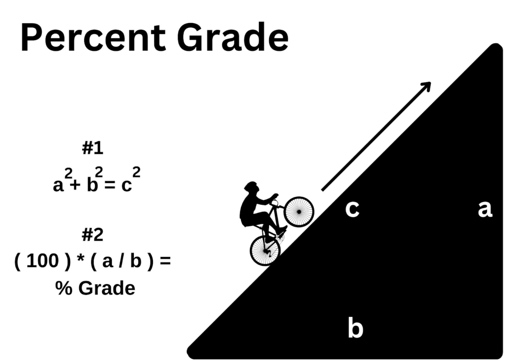
Alexander Avenue from the base of Sausalito goes up about 250 feet in 1.5 miles (7920 feet). So let’s calculate the percent grade of this hill.
According to the Pythagorean theorem, we know that:
- a2 + b2 = c2
Known:
- a = 250 feet
- b=?
- c=7920 feet
Therefore:
- a2 + b2 = c2
Insert known variables:
- 2502 + b2 = 79202
Square both known variables.
- 62500 + b2= 62726400
Subtract 62500 from each side of the equation.
- b2 = 62663900
Square root each side of the equation.
- b=7916 feet
This is b, our “run” variable.
Now we use the rise over run formula which is #2 in the image above.
- 100 * ( a / b ) = % Grade
Insert known variables.
- 100 * ( 250 / 7916 ) = % Grade
- Answer: 3.2% Grade
Note: Grades between 8% and 12% are a challenge for most.
Why is cycling grade useful?
Understanding cycling grades is useful for planning a ride along your route. You are then able to ask yourself what grades you are comfortable with, and plan accordingly.
What is considered steep in the Bay Area?
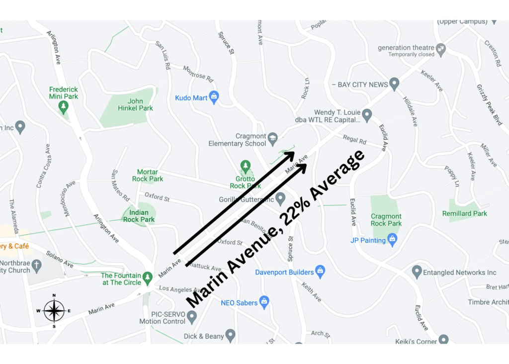
For the most part in the Marin South Country there are few times you will run into a sustained grade above 12%. What is great about South Marin County is that there are a ton of these hills around that grade. In San Francisco, there are plenty of city blocks that go above 15% grade like the one leading to my front doorstep. Notable ascents in the East Bay include Marin Avenue in Berkely approaching Grizzly Peak Boulevard (~22%) and in the South Bay Mt. Umunhum (~10%-11% average).
Conclusion
From this post you should have a good working knowledge of both elevation gain and also percent grade. What is elevation gain in cycling? Elevation gain is the measure of how much you have risen along your route. The main three metrics to look at when measuring your elevation are cumulative elevation gain, net elevation gain, and percent grade. This will paint the best picture of your ride to be able to understand what you have done before, currently are tackling and looking to ride next.